
Deskripsi
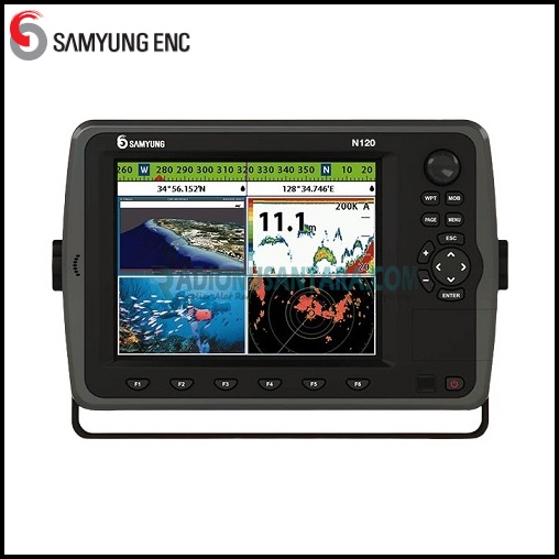
SAMYUNG N120 GPS 3D Color Chartplotter & Fishfinder
The SAMYUNG N120 GPS 3D Color Chartplotter & Fishfinder brings together advanced navigation and fishfinding capabilities in one comprehensive marine device. With its innovative 3D chartplotting technology, high-resolution display and powerful sonar features, the N120 provides a great experience for marine enthusiasts and professional anglers.
Features
- 3D map developed with SAMYUNG ENC’ / NAVIONICS® proprietary technology
- High intensity and high definition display with high resolution TFT LED applied
- LED backlighting adjustable to 10 different brightness levels
- NAVIONICS® Platinum+ available utilizing SD card input
- Plays movies, videos and music from SD or USB input
- 512/1024MB internal memory and embedded with standard SAMYUNG S-MAP
- Individual navigation GOTO & MOB buttons
- NMEA (0183/2000) interface (AIS, NAVTEX, DSC, Data repeater, Fuel control etc.)
- Multiple language support (English, Chinese, Russian, etc.)
- DGPS (including WAAS, MSAS, EGNOS) provide greatest accuracy possible
- Excellent user-friendly menu and icons
- Perfect navigational interface with Auto Pilot / Engine Controls
- Utilizes dual frequency system (50/200 kHz) for detection of small fish groups
- Features upgraded auto range, gain output and pulse length in our latest fish finding circuitry
- Utilizes high performance transduce for detection of individual and small fish
Specifications
| MODEL | N120 |
| Display | 12.1” (1024 x 768 pixels) LED Backlight |
| Receiving Channel & Tracking Satellite | 50 Channels 16 Satellites / Digital 16 Channels multi-tracking type |
| Supply Voltage | 11 to 35V DC Approx. 40W |
| Operating Temperature | -10°C to 50°C |
| Display Mode | Normal, true-motion, course-up, north up, head-up function |
| Alarms | Arrival radius, anchor, XTE, danger, too shallow, too deep, fish, temperature, temperature rate, low battery, low fuel(optional), loss of DGPS fix, radar guard zone, dangerous AIS vessels |
| Chart/User Card | SAMYUNG 2D/3D, NAVIONICS® Platinum+ / SD Card 2 slot, USB 1slot |
| Waypoints | 30,000 waypoints (Event Mark: 48, Mark Color: 16) |
| Routes | 100 Routes, with up to 100 points each |
| Tracks | By time or distance, 10 tracks of 30,000 points |
| Chart Datums | 216 Chart datums (1/2000~1/37,500,000) |
| Chart Scale | 0.2 ~ 500 nm |
| Interface | NMEA 0183, NMEA 2000 |
| Frequency | 50/200kHz |
| Output | 600W/1KW |
| Depth Range | Min: 0m – 3m; Max: 0m – 1500m |
| Color Display | 16 colors |
| Brightness | 10-step |
| Screen Moving Speed | Super-Fast, Fast, Medium, Low, Stop |
| Battery Voltage Display | Voltage Number Display |
| AUTO GAIN Adjustment | OFF/ON |
| A-Mode Display | OFF/ON |
| Demo Display | OFF/ON |
| Weak Color Removal | 0% – 75% |
| DIMENSIONS | 385 (W) x 270 (H) mm |
| STANDARD EQUIPMENT LIST | GPS 3D Chartplotter & Combo GPS Antenna Transducer Installation Materials Spare Parts Manual |


Ulasan
Belum ada ulasan.