
Deskripsi
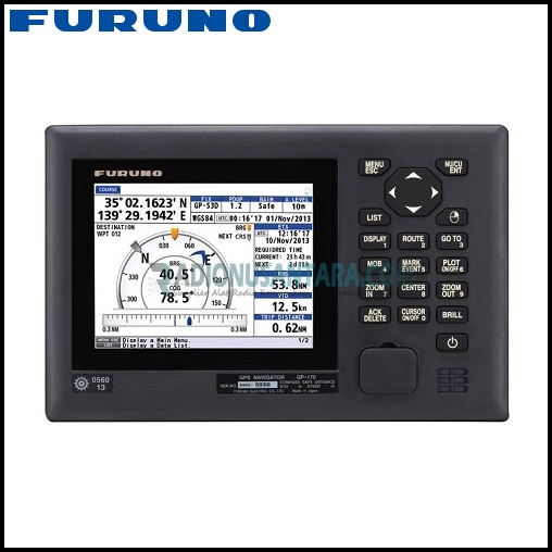
FURUNO GP-170 GPS Navigator (Global Navigation Satellite System)
The FURUNO GP-170 is a high-precision Global Navigation Satellite System (GNSS) receiver designed for marine applications. It offers a range of features and benefits, making it a reliable and versatile navigation tool for commercial and recreational vessels.

Features
- Full Compliance with IMO Performance Standards and IEC Testing Standards
High Performance for Radar, AIS, ECDIS, Autopilot, Eco Sounder, other Sensors for Navigation and Communication Equipment.
| Function | IMO Port. Standard | IEC Test Standard |
| GPS | MSC. 112 (73) | IEC61108-1 |
| GLONASS | MSC. 113 (73) | IEC61108-2 |
| DGNSS | MSC. 114 (73) | IEC61108-4 |
| MULTI* | MSC. 115 (73) | – |
| Alert Management | MSC. 302 (87) | IEC62923-1/-2 |
* Combined GPS/GLONASS
- Newly Designed GPS Chip and Antenna Unit Deliver Enhanced Stability and Precision in Position Fixing
Enhanced noise rejection capabilities are incorporated in the GPS receiver chip, delivering high level of tolerance towards multi-path mitigation. Also, the tolerance towards multi-path mitigation its enhanced when the antenna unit is used. - Augmentation to Enhance Precision by Utilizing SBAS (Satellite-Based Augmentation System), DGNSS (Differential Global Navigation Satellite System) and SLAS (Sub-meter Level Augmentation Service)
- 10Hz Position Update Rate (Position Update Every 0.1 second) making Steady Own Ship Position Tracking Possible
- USB Port Available on the Front Panel
Routing data, menu setting, user-setting can exported/imported through USB jump drives. - Dual Configuration for Back-Up Purpose to Ensure System Availability
Information about waypoints, route and other data set by the operation on one-unit cab be shared with the other unit for functional back-up. - BAM (Bridge Alert Management) Ready
Meets the specific requirements for alerts and interconnection with Bridge Alert Management in IMO MSC.302 (87). - LAN Interface for Efficient Network Integration into a Bridge System
The GP-170 is fully Light Weight Ethernet (IEC 61162-450) compatible. - 5.7” Color LCD (with 640 x 480 pixels) for Data Visualization
- Simplified Menu Operation
The operator can navigate through the menu tree either by pressing the cursor pad or pressing the corresponding numbers on the numeric keypad to the menu items. - Enhanced Route Planning/Management Function Available
-Comprehensive range of voyage information to the incorporated in routes.
-Streamlined route creation through combination with an external PC (GPX formats).
-Sharing the active route information with ECDIS to supplement the ECDIS route monitoring capability.
Specifications
GENERAL |
||
| Product Name | GNSS NAVIGATOR | |
RECEIVER |
||
| Number of Channels | GPS | 12 Ch. |
| SBAS | 2 ch | |
| QZSS | 4 ch | |
| GLONASS | 10 ch | |
| RX Frequency | GPS/SBAS/QZSS | 1575.42MHz ±1.023MHz |
| GLONASS | 1602.5625MHz | |
| Tracking Code | GPS | C/A |
| SBAS | C/A | |
| QZSS | C/A. L1S | |
| GLONASS | L10F | |
| Accuracy* | GPS | not exceeding 10 m (2 drms, HD0P<4) |
| DGPS | not exceeding 5 m (2 drms, HD0P<4) | |
| WAAS | not exceeding 3 m (2 drms, HD0P<4) | |
| MSAS | not exceeding 7 m (2 drms, HD0P<4) | |
| QZSS (SLAS) L1S | not exceeding 3 m (2 drms, HD0P<4) | |
| Tracking Velocity | 1,000 kn | |
| Time to First Fix | 90 sec when cold start | |
| Position Update Rate | Every 1 sec (standard); every 0.1 sec (max)* * not available for GLONASS and SLAS modes |
|
| Beacon Receiver (optional internal kit) | Frequency Range | 283.5 to 325.0kHz |
| MSK Rate | 25*, 50, 100, 150, 200 bps * GLONASS only |
|
| * Dependent on ionospheric activity and multipath | ||
DISPLAY UNIT |
||
| Screen Size | 5.7” color LCD (116.16 mm x 87.12 mm) | |
| Resolution | 640 (H) x 480 (V) pixels (VGA) | |
| Brightness | 700 cd/m² | |
| DSC Receiver | 156.525 MHz, CH70 fixed | |
| Display Modes | Plotter, Highway, Course, Data, Integrity | |
| Plotter Mode | Projection | Mercator |
| Memory Capacity | 1,000 points for ship’s track with comments up to 20 characters; 2,000 points for waypoints; 100 routes (containing up to 1,000 waypoints per 1 route) | |
| Integrity Mode | GNSS, Graph, Beacon | |
| Alert | Differential positioning interruption, HDOP overshoot, own ship positioning fails, own ship position lost, beacon signal lost, beacon malfunction, antenna short-circuit | |
| Notice | Arrival and Anchor Watch, XTE, Speed, Trip | |
| Integrity Indication | Safe, Unsafe, Caution | |
INTERFACE |
||
| Ports | Serial ports: 2 ports (In/Out, 1 port (Out) IEC 61162-a, 1 pot (In/Out) IEC 61162-2; Ethernet: 1 port IEC 61162-450; USB: 1 port (front panel) |
|
| Output | Serial | AAM, ALC, ALF, ALR, APA, ARC, BOD, BWC, BWR, BWW, DTM, GBS, GGA*, GLL, GNS, GRS, GSA, GST, GSV, HBT, MSK**, MSS***, POS, QSM, RMB, RMC, Rnn, RTE, VDR, VTG, WCV, WNC, WNR, WPL, XTE, ZDA, RTCM sc104 ** when either internal/external beacon receiver is used *** when internal beacon receiver is used |
| Ethernet | AAM, ALC, ALF, ALR, APB, ARC, BOD, BWC, BWR, BWW, DTM, GBS, GGA*, GLL, GNS, GRS, GSA, GST, GSV, HBT, POS, QSM, RMB, RMC, RTE, VDR, VTG, WCV, WNC, WPL, XTE, ZDA | |
| Input | Serial | ACK, CAN, CRQ, DBT, DPT, HBT, HDG, HDM, HDT, MSK, MSS, MTW, THS, TLL, VBW, VHW |
| Ethernet | ACK, ACN, DBT, DPT, HBT, HDG, HDM, HDT, MTW, THS, TLL, VBW, VHW | |
| * Not available when using GLONASS | ||
POWER SUPPLY |
12 – 24V DC | |
ENVIRONMENT |
||
| Temperature | Display Unit | -15°C to +55°C |
| Antenna Unit | -25°C to +70°C | |
| Relative Humidity | 95% or Less at 40°C | |
| Degree of Protection | Display Unit | IP25 |
| Antenna Unit | IP56 | |
EQUIPMENT LIST |
Display Unit GP-170 Antenna Unit GPA-017S, GPA-020S, GPA-021S*, GPA-022S, GPS-023S* (* Selectable when a beacon receiver is incorporated into a display unit.) Antenna Cables (Selectable from 15m / 30m / 40m / 50m) Installation Materials and Spare Parts |
|
| Datasheet | GP-170_EN | |


Ulasan
Belum ada ulasan.